

Creating Bush Trips for VORNDB navigation is fun and quite different from selecting airports and waypoints to make a flight plan. In cooperation with ProfSC this trip is created.
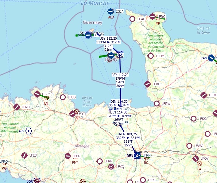
So here is a short trip in Brittany and the English Channel where you have to find your way around by looking outside and using the VOR and NDB instrumentation to navigate. The trip starts in Lannion, France and you navigate on NBD beacons to the airport of Pleurtuit-St Malo. There is your first stop. The next legs you navigate using VOR to Jersey and from there the Guernsey.
Total length of the trip is 140 nm and takes 3 legs.
The Cessna 152 is the plane for this trip because this plane has two VOR radios. You have to do some cross flying on the radials of the VORs. There no GPS available, not even after you change to an aircraft which is equipped with GPS receivers.
You start at the parking with the plane cold and dark.
The weather is adjustable.
The trip multilingual with thirteen languages, Chinese is not available. Apart from English all languages are machine translated.
In the zip file you find a flight book in English. This is for pilots who like their instruction on a piece of paper, so they can read them.
In the zip-file you will find:
The flight book with a complete description, waypoint text etc.
Map from Little Navmap with the flight plan.
Map from Little Navmap with the VOR beacons.
The next add-ons are not mandatory, but strongly recommended to enhance your experience.
Dinard city, France by Comolas
Saint-Malo, Walled City by Thalixte
Saint-Malo - Dinard by Thalixte
Channel Islands Airports Upgrade - Jersey, Guernsey, Alderney
Thanks to the creators of these add-ons.
Thanks to Alexander Barthel for Little Navmap and thanks to BuffyGC for his outstanding BushTripInjector.
And we thank each other for the cooperation in this project.
For you: Happy flying and safe landings.

 Frontech


Nice trip especially if you are trying to learn radio navigation. Well done!
2 years ago
It was made with that purpose, use non-precision navigation instead of GPS. Thanks for your comment.
2 years ago
Frontech
wfrayer
Hooray, more love for our dear Channel Islands, thank you 👍👏
2 years ago
I am pleased I can do this for you. Thank you for your reaction.
2 years ago
Frontech
Shado2k